

Leaflet 1.1.0 is now available on CRAN! The Leaflet package is a tidy wrapper for the Leaflet.js mapping library, and makes it incredibly easy to generate interactive maps based on spatial data you have in R.

Leaflet is one of the most popular open-source JavaScript libraries for interactive maps. It’s used by websites ranging from The New York Times and The Washington Post to GitHub and Flickr , as well as GIS specialists like OpenStreetMap , Mapbox , and CartoDB
This release was nearly a year in the making, and includes many important new features.
- Easily add textual labels on markers, polygons, etc., either on hover or statically
- Highlight polygons, lines, circles, and rectangles on hover
- Markers can now be configured with a variety of colors and icons, via integration with Leaflet.awesome-markers
-
Built-in support for many types of objects from
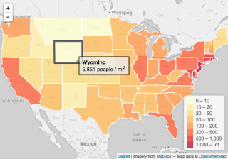
sf, a new way of representing spatial data in R (all basicsf/sfc/sfgtypes exceptMULTIPOINTandGEOMETRYCOLLECTIONare directly supported) - Projections other than Web Mercator are now supported via Proj4Leaflet
-
Color palette functions now natively support
viridis
palettes; use
"viridis","magma","inferno", or"plasma"as the palette argument -
Discrete color palette functions (
colorBin,colorQuantile, andcolorFactor) work much better with color brewer palettes - Integration with several Leaflet.js utility plugins
-
Data with
NApoints or zero rows no longer causes errors - Support for linked brushing and filtering, via Crosstalk (more about this to come in another blog post)
Visto en
blog.rstudio